
File:Confluence on the Slade Brook - geograph.org.uk - 520343.jpg
No higher resolution available.
Confluence_on_the_Slade_Brook_-_geograph.org.uk_-_520343.jpg (640 × 480 pixels, file size: 128 KB, MIME type: image/jpeg)
| This is a file from the Wikimedia Commons. Information from its description page there is shown below. Commons is a freely licensed media file repository. You can help. |
Summary
| Description |
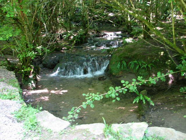
English: Confluence on the Slade Brook This is very near the source of the Slade Brook which is piped at this spot for a track which runs(left)up to Bearse Common. The image also shows the brook flowing over some of the Tufa Dams which are numerous in this valley; formed due to the high calcium carbonate mineral content of the water emerging from springs in the local limestone. |
| Date | |
| Source | From geograph.org.uk |
| Author | Roy Parkhouse |
| Attribution (required by the license) | Roy Parkhouse / Confluence on the Slade Brook / |
| Camera location | | View this and other nearby images on: OpenStreetMap |
|---|
_heading:45.00&language=en)
| Object location | | View this and other nearby images on: OpenStreetMap |
|---|
_heading:45.00&language=en)
Licensing

|
This image was taken from the Geograph project collection. See this photograph's page on the Geograph website for the photographer's contact details. The copyright on this image is owned by Roy Parkhouse and is licensed for reuse under the Creative Commons Attribution-ShareAlike 2.0 license.
|
This file is licensed under the Creative Commons Attribution-Share Alike 2.0 Generic license.
Attribution: Roy Parkhouse
- You are free:
- to share – to copy, distribute and transmit the work
- to remix – to adapt the work
- Under the following conditions:
- attribution – You must give appropriate credit, provide a link to the license, and indicate if changes were made. You may do so in any reasonable manner, but not in any way that suggests the licensor endorses you or your use.
- share alike – If you remix, transform, or build upon the material, you must distribute your contributions under the same or compatible license as the original.
- Remove redundant categories and try to put this image in the most specific category/categories
- Remove this template
- The location categories are based on information from this geonames tool and this OpenStreetMap tool combined with a database. You can also have a look at this tool from mysociety.
- The topic category from Geograph was Confluence (find similar images at Geograph)
File history
Click on a date/time to view the file as it appeared at that time.
| Date/Time | Thumbnail | Dimensions | User | Comment | |
|---|---|---|---|---|---|
| current | 15:51, 5 February 2011 | | 640 × 480 (128 KB) | GeographBot | == {{int:filedesc}} == {{Information |description={{en|1=Confluence on the Slade Brook This is very near the source of the Slade Brook which is piped at this spot for a track which runs(left)up to Bearse Common. The image also shows the brook flowing over |
File usage
The following pages on the English Wikipedia use this file (pages on other projects are not listed):
Global file usage
The following other wikis use this file:
- Usage on www.wikidata.org