
File:Clay Cross station site geograph-3110788-by-Ben-Brooksbank.jpg

Size of this preview: 800 × 471 pixels. Other resolutions: 320 × 189 pixels | 640 × 377 pixels | 1,024 × 603 pixels | 1,280 × 754 pixels | 2,349 × 1,384 pixels.
Original file (2,349 × 1,384 pixels, file size: 2.96 MB, MIME type: image/jpeg)
| This is a file from the Wikimedia Commons. Information from its description page there is shown below. Commons is a freely licensed media file repository. You can help. |
Summary
| Description |
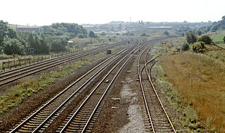
English: Site of Clay Cross station, 1983, View southward on ex-Midland trunk lines, from Sheffield, Leeds etc, via Chesterfield, towards Nottingham and the South by the Erewash Valley line (to left), Derby, Birmingham and the South-West (to the right). In former days, 20+ years before, there would always have been at least one train in this scene, but in 1983 - even on a Summer Saturday there was nothing in sight. Virtually no trace of the four-platform station can be seen either. |
| Date | |
| Source | From geograph.org.uk |
| Author | Ben Brooksbank |
| Permission (Reusing this file) |
Creative Commons Attribution Share-alike license 2.0 |
| Attribution (required by the license) | Ben Brooksbank / Site of Clay Cross station, 1983 / |
| Camera location | | View this and other nearby images on: OpenStreetMap |
|---|
Licensing

|
This image was taken from the Geograph project collection. See this photograph's page on the Geograph website for the photographer's contact details. The copyright on this image is owned by Ben Brooksbank and is licensed for reuse under the Creative Commons Attribution-ShareAlike 2.0 license.
|
This file is licensed under the Creative Commons Attribution-Share Alike 2.0 Generic license.
Attribution: Ben Brooksbank
- You are free:
- to share – to copy, distribute and transmit the work
- to remix – to adapt the work
- Under the following conditions:
- attribution – You must give appropriate credit, provide a link to the license, and indicate if changes were made. You may do so in any reasonable manner, but not in any way that suggests the licensor endorses you or your use.
- share alike – If you remix, transform, or build upon the material, you must distribute your contributions under the same or compatible license as the original.
File history
Click on a date/time to view the file as it appeared at that time.
| Date/Time | Thumbnail | Dimensions | User | Comment | |
|---|---|---|---|---|---|
| current | 06:48, 23 September 2012 | | 2,349 × 1,384 (2.96 MB) | Chevin | == {{int:filedesc}} == {{Information |Description={{en|1='''Site of Clay Cross station, 1983,'''<br/> View southward on ex-Midland trunk lines, from Sheffield, Leeds etc, via Chesterfield, towards Nottingham and the South by the Erewash Valley line (to... |
File usage
The following pages on the English Wikipedia use this file (pages on other projects are not listed):
Global file usage
The following other wikis use this file:
- Usage on arz.wikipedia.org
- Usage on www.wikidata.org