
File:Clapham Junction 1988 incident 2 geograph-3149688-by-Ben-Brooksbank.jpg

Size of this preview: 800 × 600 pixels. Other resolutions: 320 × 240 pixels | 640 × 480 pixels | 1,024 × 768 pixels | 1,280 × 960 pixels | 1,920 × 1,440 pixels.
Original file (1,920 × 1,440 pixels, file size: 3.25 MB, MIME type: image/jpeg)
| This is a file from the Wikimedia Commons. Information from its description page there is shown below. Commons is a freely licensed media file repository. You can help. |
Summary
| Description |
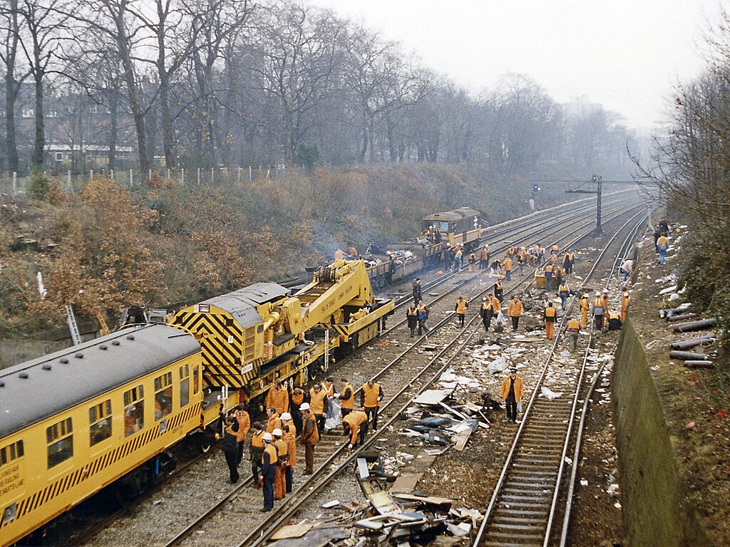
English: Clearing up after the December 1988 crash west of Clapham Junction. View SW towards Wimbledon etc. from the Battersea Rise bridge/Spencer Park Road on the day after a bad accident had occurred on the Up lines (nearest) at 08.10 the previous morning, in which 35 people were killed and over 500 injured. Owing to an installation fault with the signalling, a crowded Up train had run into the rear of another and the wreckage was then struck by a Down empty train. The view shows all four ex-LSWR tracks of the main Waterloo - Wimbledon - Woking and the West line blocked by the breakdown-train men at work more than 24 hours afterwards. The numerous casualties had been brought up the bank on the right to Spencer Park Road. (See also TQ2674 : Clearing up after the December 1988 crash west of Clapham Junction). |
| Date | |
| Source | From geograph.org.uk |
| Author | Ben Brooksbank |
| Permission (Reusing this file) |
Creative Commons Attribution Share-alike license 2.0 |
| Camera location | | View this and other nearby images on: OpenStreetMap |
|---|
Licensing

|
This image was taken from the Geograph project collection. See this photograph's page on the Geograph website for the photographer's contact details. The copyright on this image is owned by Ben Brooksbank and is licensed for reuse under the Creative Commons Attribution-ShareAlike 2.0 license.
|
This file is licensed under the Creative Commons Attribution-Share Alike 2.0 Generic license.
Attribution: Ben Brooksbank
- You are free:
- to share – to copy, distribute and transmit the work
- to remix – to adapt the work
- Under the following conditions:
- attribution – You must give appropriate credit, provide a link to the license, and indicate if changes were made. You may do so in any reasonable manner, but not in any way that suggests the licensor endorses you or your use.
- share alike – If you remix, transform, or build upon the material, you must distribute your contributions under the same or compatible license as the original.
File history
Click on a date/time to view the file as it appeared at that time.
| Date/Time | Thumbnail | Dimensions | User | Comment | |
|---|---|---|---|---|---|
| current | 22:00, 11 December 2016 | | 1,920 × 1,440 (3.25 MB) | David Levy | cropped |
| 19:37, 6 October 2012 |  | 2,267 × 1,448 (3.93 MB) | Chevin | == {{int:filedesc}} == {{Information |Description={{en|1='''Clearing up after the December 1988 crash west of Clapham Junction.'''<br/> View SW towards Wimbledon etc. from the Battersea Rise bridge/Spencer Park Road on the day after a bad accident had ... |
File usage
The following pages on the English Wikipedia use this file (pages on other projects are not listed):
Global file usage
The following other wikis use this file:
- Usage on de.wikipedia.org
- Usage on el.wikipedia.org
- Usage on www.wikidata.org