
File:CNF Wilderness Map.jpg

Size of this preview: 790 × 600 pixels. Other resolutions: 316 × 240 pixels | 632 × 480 pixels | 1,009 × 766 pixels.
Original file (1,009 × 766 pixels, file size: 195 KB, MIME type: image/jpeg)
| This is a file from the Wikimedia Commons. Information from its description page there is shown below. Commons is a freely licensed media file repository. You can help. |
Summary
| Description |
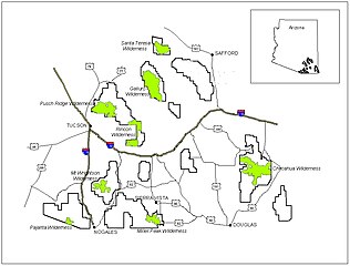
English: Map of designated wilderness areas within the Coronado National Forest of southeastern Arizona. |
|||
| Source | U.S. Forest Service—[1] | |||
| Author | USFS | |||
| Permission (Reusing this file) |
|
en:Category:Coronado National Forest
File history
Click on a date/time to view the file as it appeared at that time.
| Date/Time | Thumbnail | Dimensions | User | Comment | |
|---|---|---|---|---|---|
| current | 23:37, 29 March 2008 | | 1,009 × 766 (195 KB) | Axcordion~commonswiki | {{Information |Description=Map of designated wilderness areas in the Coronado National Forest of southeast Arizona, USA. |Source=U.S. Forest Service[http://www.fs.fed.us/r3/coronado/forest/recreation/wilderness/wilderness_map.shtml] |Date= |Author=USFS |P |
File usage
The following pages on the English Wikipedia use this file (pages on other projects are not listed):
Global file usage
The following other wikis use this file:
- Usage on ca.wikipedia.org
- Usage on de.wikipedia.org
- Usage on eo.wikipedia.org
- Usage on es.wikipedia.org
- Usage on fa.wikipedia.org
- Usage on it.wikipedia.org
- Usage on ro.wikipedia.org