
File:Bozeman Trail, the forts and the Indian territories.jpg

Size of this preview: 502 × 599 pixels. Other resolutions: 201 × 240 pixels | 402 × 480 pixels | 644 × 768 pixels | 858 × 1,024 pixels | 1,720 × 2,052 pixels.
Original file (1,720 × 2,052 pixels, file size: 458 KB, MIME type: image/jpeg)
| This is a file from the Wikimedia Commons. Information from its description page there is shown below. Commons is a freely licensed media file repository. You can help. |
Summary
| Description |
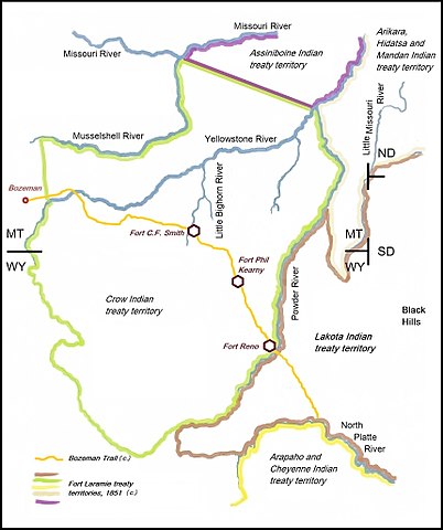
English: Bozeman Trail, Fort C.F. Smith, Fort Phil Kearny and Fort Reno and relevant Indian territories of 1851, (Assiniboine, Crow. Partly Lakota, Arikara, Hidatsa, Mandan, Cheyenne and Arapaho) |
| Date | |
| Source | Own work |
| Author | Naawada2016 |
North America, U.S., Montana and Wyoming, Crow Indian treaty terriotry (1851)
Licensing
I, the copyright holder of this work, hereby publish it under the following license:
This file is licensed under the Creative Commons Attribution-Share Alike 4.0 International license.
- You are free:
- to share – to copy, distribute and transmit the work
- to remix – to adapt the work
- Under the following conditions:
- attribution – You must give appropriate credit, provide a link to the license, and indicate if changes were made. You may do so in any reasonable manner, but not in any way that suggests the licensor endorses you or your use.
- share alike – If you remix, transform, or build upon the material, you must distribute your contributions under the same or compatible license as the original.
File history
Click on a date/time to view the file as it appeared at that time.
| Date/Time | Thumbnail | Dimensions | User | Comment | |
|---|---|---|---|---|---|
| current | 12:11, 22 June 2017 | | 1,720 × 2,052 (458 KB) | Naawada2016 | User created page with UploadWizard |
File usage
The following pages on the English Wikipedia use this file (pages on other projects are not listed):
Global file usage
The following other wikis use this file:
- Usage on arz.wikipedia.org
- Usage on cs.wikipedia.org
- Usage on it.wikipedia.org
- Usage on pl.wikipedia.org
- Usage on www.wikidata.org