
File:BostMtnOv2.png
No higher resolution available.
BostMtnOv2.png (800 × 391 pixels, file size: 171 KB, MIME type: image/png)
| This is a file from the Wikimedia Commons. Information from its description page there is shown below. Commons is a freely licensed media file repository. You can help. |
| Description |
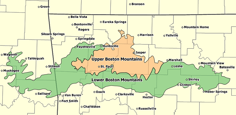
English: Overview map of the Boston Mountains in Arkansas and Oklahoma. Shows the location of the Upper Boston Mountains and Lower Boston Mountains based on Ecoregion IV definitions, County boundaries, and Cities and Towns. |
| Date | |
| Source | Own work |
| Author | Tosborn (talk) (Uploads) |
Summary
Overview map of the Boston Mountains in Arkansas and Oklahoma. Shows the location of the Upper Boston Mountains and Lower Boston Mountains based on Ecoregion IV definitions, County boundaries, and Cities and Towns.
Licensing
| I, the copyright holder of this work, release this work into the public domain. This applies worldwide. In some countries this may not be legally possible; if so: I grant anyone the right to use this work for any purpose, without any conditions, unless such conditions are required by law. |
File history
Click on a date/time to view the file as it appeared at that time.
| Date/Time | Thumbnail | Dimensions | User | Comment | |
|---|---|---|---|---|---|
| current | 04:43, 12 January 2007 | | 800 × 391 (171 KB) | Tosborn | Overview map of the Boston Mountains in Arkansas and Oklahoma. Shows the location of the Upper Boston Mountains and Lower Boston Mountains based on Ecoregion IV definitions, County boundaries, and Cities and Towns. |
File usage
The following pages on the English Wikipedia use this file (pages on other projects are not listed):