
File:Bath House - geograph.org.uk - 1371580.jpg
No higher resolution available.
Bath_House_-_geograph.org.uk_-_1371580.jpg (640 × 426 pixels, file size: 59 KB, MIME type: image/jpeg)
| This is a file from the Wikimedia Commons. Information from its description page there is shown below. Commons is a freely licensed media file repository. You can help. |
Summary
}
| Description |
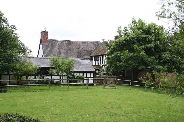
English: Bath House Genuine Tudor, by the look of it. I suspect the name relates to Spurstow Spa, the site of which is in a wood to the southeast. The waters were said to have medicinal properties, and Sir Thomas Mostyn built baths here which were said to be "much frequented" in the 1700s. By 1848 they were reported as "not at present in repute", although an analysis of the water found it to be rich in sulphates of sodium and magnesium. |
| Date | |
| Source | From geograph.org.uk |
| Author | Dave Dunford |
| Attribution (required by the license) | Dave Dunford / Bath House / |
| Camera location | | View this and other nearby images on: OpenStreetMap |
|---|
_heading:180.00&language=en)
| Object location | | View this and other nearby images on: OpenStreetMap |
|---|
_heading:180.00&language=en)
{{Listed building England|1312873}
Licensing

|
This image was taken from the Geograph project collection. See this photograph's page on the Geograph website for the photographer's contact details. The copyright on this image is owned by Dave Dunford and is licensed for reuse under the Creative Commons Attribution-ShareAlike 2.0 license.
|
This file is licensed under the Creative Commons Attribution-Share Alike 2.0 Generic license.
Attribution: Dave Dunford
- You are free:
- to share – to copy, distribute and transmit the work
- to remix – to adapt the work
- Under the following conditions:
- attribution – You must give appropriate credit, provide a link to the license, and indicate if changes were made. You may do so in any reasonable manner, but not in any way that suggests the licensor endorses you or your use.
- share alike – If you remix, transform, or build upon the material, you must distribute your contributions under the same or compatible license as the original.
File history
Click on a date/time to view the file as it appeared at that time.
| Date/Time | Thumbnail | Dimensions | User | Comment | |
|---|---|---|---|---|---|
| current | 14:05, 28 February 2011 | | 640 × 426 (59 KB) | GeographBot | == {{int:filedesc}} == {{Information |description={{en|1=Bath House Genuine Tudor, by the look of it. I suspect the name relates to Spurstow Spa, the site of which is in a wood to the southeast. The waters were said to have medicinal properties, and Sir T |
File usage
The following pages on the English Wikipedia use this file (pages on other projects are not listed):
Global file usage
The following other wikis use this file:
- Usage on www.wikidata.org