
File:Aldwych in 1900 (station location).png
No higher resolution available.
Aldwych_in_1900_(station_location).png (409 × 295 pixels, file size: 284 KB, MIME type: image/png)
| This is a file from the Wikimedia Commons. Information from its description page there is shown below. Commons is a freely licensed media file repository. You can help. |
.png)
| Description |
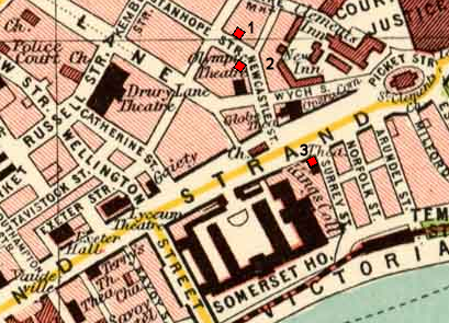
Map of Aldwych area of London circa 1900, annotated with the planned and final locations of Aldwych underground station: |
| Date | |
| Source |
Map taken from Plate 7 of "The Pocket Atlas & Guide to London" by John Bartholomew and Son. |
| Author | Base map by unknown artist, published by John Bartholomew and Son circa 1900. |
| Permission (Reusing this file) |
see below |
This file is licensed under the Creative Commons Attribution 3.0 Unported license.
- You are free:
- to share – to copy, distribute and transmit the work
- to remix – to adapt the work
- Under the following conditions:
- attribution – You must give appropriate credit, provide a link to the license, and indicate if changes were made. You may do so in any reasonable manner, but not in any way that suggests the licensor endorses you or your use.
File history
Click on a date/time to view the file as it appeared at that time.
| Date/Time | Thumbnail | Dimensions | User | Comment | |
|---|---|---|---|---|---|
| current | 15:38, 26 July 2011 | | 409 × 295 (284 KB) | McGeddon~commonswiki | scratch that - this loses the precise locations at the expense of thumbnail clarity, so probably isn't worth it |
| 15:35, 26 July 2011 |  | 409 × 295 (299 KB) | McGeddon~commonswiki | Indicating the three sites more prominently. | |
| 22:07, 22 July 2010 |  | 409 × 295 (284 KB) | DavidCane | smaller version | |
| 22:01, 22 July 2010 |  | 684 × 524 (785 KB) | DavidCane | {{Information |Description=Map of Aldwych area of London circa 1900, annotated with the planned and final locations of Aldwych underground station:<br> 1. Planned location; corner of Stanhope & Holles Street (not s |
File usage
The following pages on the English Wikipedia use this file (pages on other projects are not listed):
Global file usage
The following other wikis use this file:
- Usage on de.wikipedia.org
- Usage on hu.wikipedia.org
- Usage on it.wikipedia.org
- Usage on nl.wikipedia.org
- Usage on zh.wikipedia.org
.png)