
File:2008 United States Senate election in West Virginia results map by county.svg

Size of this PNG preview of this SVG file: 675 × 599 pixels. Other resolutions: 270 × 240 pixels | 541 × 480 pixels | 865 × 768 pixels | 1,154 × 1,024 pixels | 2,307 × 2,048 pixels | 810 × 719 pixels.
Original file (SVG file, nominally 810 × 719 pixels, file size: 38 KB)
| This is a file from the Wikimedia Commons. Information from its description page there is shown below. Commons is a freely licensed media file repository. You can help. |
Summary
| Description |
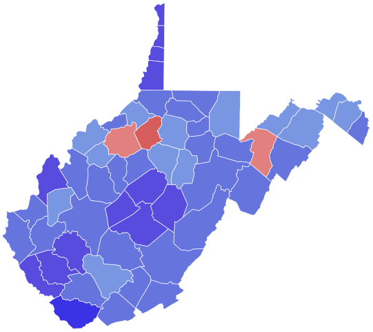
English: 2008 US Senate elections in West Virginia by county.
Wolfe >= 50%
Wolfe >= 60%
Rockefeller >= 50%
Rockefeller >= 60%
Rockefeller >= 70%
Rockefeller >= 80% |
| Date | |
| Source | File:West Virginia Republican Presidential Primary Election Results by County, 2012.svg (public domain) |
| Author |
Licensing
I, the copyright holder of this work, hereby publish it under the following license:
| This file is made available under the Creative Commons CC0 1.0 Universal Public Domain Dedication. | |
| The person who associated a work with this deed has dedicated the work to the public domain by waiving all of their rights to the work worldwide under copyright law, including all related and neighboring rights, to the extent allowed by law. You can copy, modify, distribute and perform the work, even for commercial purposes, all without asking permission.
|
File history
Click on a date/time to view the file as it appeared at that time.
| Date/Time | Thumbnail | Dimensions | User | Comment | |
|---|---|---|---|---|---|
| current | 17:13, 30 December 2023 | | 810 × 719 (38 KB) | Putitonamap98 | shapes |
| 18:07, 11 January 2023 |  | 744 × 666 (363 KB) | Putitonamap98 | Reverted to version as of 21:26, 8 January 2023 (UTC) | |
| 10:09, 11 January 2023 |  | 290 × 276 (32 KB) | T4ggt4gt4 | Reverted to version as of 19:07, 8 January 2023 (UTC) | |
| 21:26, 8 January 2023 |  | 744 × 666 (363 KB) | Putitonamap98 | Reverted to version as of 23:14, 2 January 2023 (UTC) | |
| 19:07, 8 January 2023 |  | 290 × 276 (32 KB) | 4334r3fg24t | Reverted to version as of 15:04, 3 April 2021 (UTC) | |
| 23:14, 2 January 2023 |  | 744 × 666 (363 KB) | Putitonamap98 | shapes | |
| 15:04, 3 April 2021 |  | 290 × 276 (32 KB) | TylerKutschbach | Reverted to version as of 03:59, 3 April 2021 (UTC) unnecessary shapes | |
| 04:54, 3 April 2021 |  | 744 × 666 (279 KB) | Elli | please discuss this, if you disagree | |
| 03:59, 3 April 2021 |  | 290 × 276 (32 KB) | TylerKutschbach | Reverted to version as of 11:08, 1 January 2017 (UTC) | |
| 23:21, 2 April 2021 |  | 744 × 666 (279 KB) | Awmcphee | Standardized geography |
File usage
The following pages on the English Wikipedia use this file (pages on other projects are not listed):
Global file usage
The following other wikis use this file:
- Usage on fi.wikipedia.org