
File:1948 Fukui earthquake intensity map.png
Size of this preview: 624 × 600 pixels. Other resolutions: 250 × 240 pixels | 499 × 480 pixels | 799 × 768 pixels | 1,065 × 1,024 pixels | 2,131 × 2,048 pixels | 3,323 × 3,194 pixels.
Original file (3,323 × 3,194 pixels, file size: 1.54 MB, MIME type: image/png)
| This is a file from the Wikimedia Commons. Information from its description page there is shown below. Commons is a freely licensed media file repository. You can help. |
Summary
| Description |
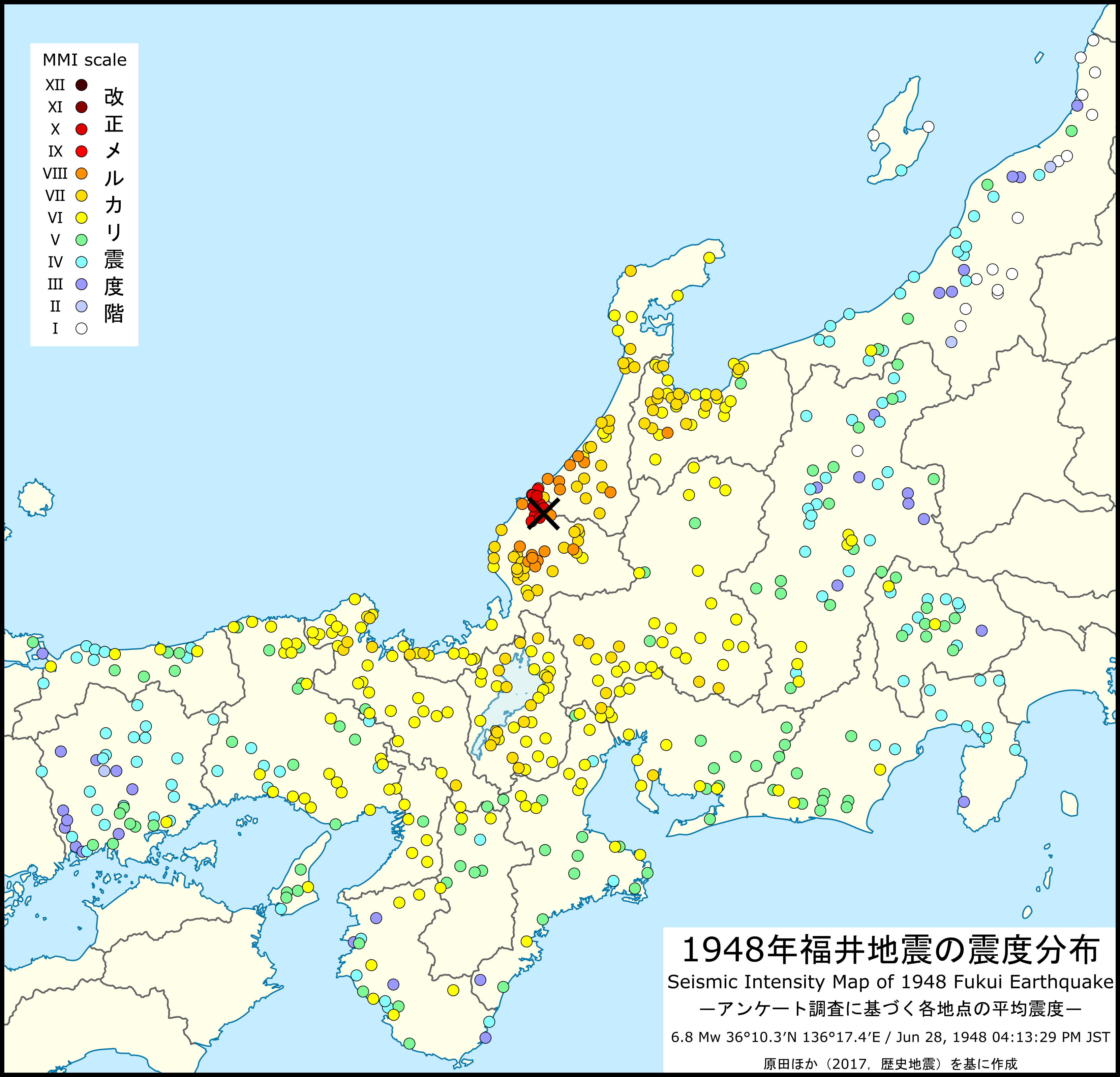
English: Seismic intensity map of 1948 Fukui earthquake on the modified Mercalli intensity scale based on a postal survey by the Earthquake Research Institute, University of Tokyo |
| Date | |
| Source | 震源要素および震度分布は[講演要旨]地震直後に行われたアンケート調査による1948年福井地震の震度分布 (Harada et al. 2017)、白地図はFile:Japan location map.svg、湖岸線(琵琶湖)はFile:Japan Shiga Prefecture location map.svgの各データをもとに作成。 |
| Author | Doraemonplus |
Licensing
I, the copyright holder of this work, hereby publish it under the following license:
This file is licensed under the Creative Commons Attribution-Share Alike 4.0 International license.
- You are free:
- to share – to copy, distribute and transmit the work
- to remix – to adapt the work
- Under the following conditions:
- attribution – You must give appropriate credit, provide a link to the license, and indicate if changes were made. You may do so in any reasonable manner, but not in any way that suggests the licensor endorses you or your use.
- share alike – If you remix, transform, or build upon the material, you must distribute your contributions under the same or compatible license as the original.
File history
Click on a date/time to view the file as it appeared at that time.
| Date/Time | Thumbnail | Dimensions | User | Comment | |
|---|---|---|---|---|---|
| current | 09:00, 5 January 2022 | | 3,323 × 3,194 (1.54 MB) | Doraemonplus | Uploaded own work with UploadWizard |
File usage
The following pages on the English Wikipedia use this file (pages on other projects are not listed):
Global file usage
The following other wikis use this file: