
File:1859 Segment of US Survey Map of San Francisco - Mission de Dolores - Las Camaritas.png

Size of this preview: 800 × 506 pixels. Other resolutions: 320 × 202 pixels | 640 × 405 pixels | 995 × 629 pixels.
Original file (995 × 629 pixels, file size: 1.18 MB, MIME type: image/png)
| This is a file from the Wikimedia Commons. Information from its description page there is shown below. Commons is a freely licensed media file repository. You can help. |
Summary
| Description |
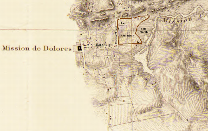
English: This is a marked up segment of the 1859 US Survey map showing Las Camaritas
Entrance to San Francisco Bay, California : from a trigonometrical survey under the direction of A.D. Bache, Superintendent of the Survey of the Coast of the United States ; triangulation by R.D. Cutts, Asst. & A.E. Rodgers, Sub-Asst. ; topography by R.D. Cutts, Asst., A.M. Harrison & A.F. Rodgers, Sub-Assts. ; hydrography by the party under the command of Lieut. Comdg. James Alden, U.S.N. Assist. Contributor Names United States Coast Survey. Bache, A. D. (Alexander Dallas), 1806-1867. Cutts, R. D. (Richard Dominicus), 1817-1883. Rodgers, A. F. Harrison, A. M. (Alexander Medina), 1829-1881. Created / Published [S.l.] : The Survey, 1859. Subject Headings - Nautical charts--California--San Francisco Bay - United States--California--San Francisco Bay Notes - Relief shown in hachures. Depths shown by contours and soundings. - Covers San Francisco Bay and adjacent water and land areas. - Available also through the Library of Congress Web site as a raster image. - Includes 1 inset, 3 coastal panoramas and sailing information. Medium 1 map ; original - 60 x 99 cm. Call Number/Physical Location G4362.S22P5 1859 .U5 Repository Library of Congress Geography and Map Division Washington, D.C. 20540-4650 USA dcu Digital Id http://hdl.loc.gov/loc.gmd/g4362s.ct001224 Library of Congress Control Number 2006635241 Online Format image Description Relief shown in hachures. Depths shown by contours and soundings. Covers San Francisco Bay and adjacent water and land areas. Available also through the Library of Congress Web site as a raster image. Includes 1 inset, 3 coastal panoramas and sailing information. LCCN Permalink https://lccn.loc.gov/2006635241 |
| Date | |
| Source | Library of Congress |
| Author |
United States Coast Survey. Bache, A. D. (Alexander Dallas), 1806-1867. Cutts, R. D. (Richard Dominicus), 1817-1883. Rodgers, A. F.Harrison, A. M. (Alexander Medina), 1829-1881. |
Licensing
This work is in the public domain in the United States because it is a work prepared by an officer or employee of the United States Government as part of that person’s official duties under the terms of Title 17, Chapter 1, Section 105 of the US Code.
Note: This only applies to original works of the Federal Government and not to the work of any individual U.S. state, territory, commonwealth, county, municipality, or any other subdivision. This template also does not apply to postage stamp designs published by the United States Postal Service since 1978. (See § 313.6(C)(1) of Compendium of U.S. Copyright Office Practices). It also does not apply to certain US coins; see The US Mint Terms of Use.
|
 | |
| This file has been identified as being free of known restrictions under copyright law, including all related and neighboring rights. | ||
File history
Click on a date/time to view the file as it appeared at that time.
| Date/Time | Thumbnail | Dimensions | User | Comment | |
|---|---|---|---|---|---|
| current | 18:15, 16 December 2017 | | 995 × 629 (1.18 MB) | Energynet | User created page with UploadWizard |
File usage
The following pages on the English Wikipedia use this file (pages on other projects are not listed):